About the Glass Window Bridge
Eleuthera, Bahamas — where two oceans meet
🌊 What Is the Glass Window Bridge?
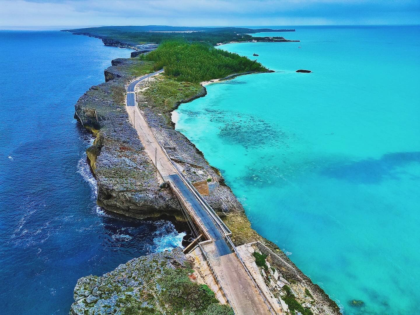
The Glass Window Bridge is one of the most dramatic and photographed landmarks in the Bahamas. Located on Eleuthera island, it sits at the island's narrowest point — a thin strip of rock barely wide enough for a two-lane road — where the deep blue Atlantic Ocean and the calm turquoise Caribbean Sea (technically the Bight of Eleuthera) lie side by side, separated by just a few meters.
The contrast between the two bodies of water is striking: the Atlantic side is typically dark navy and churning, while the Caribbean side shimmers in brilliant turquoise. The effect is like looking through a glass window between two worlds — which is exactly how the bridge got its name.
The current structure is a concrete road bridge that allows vehicles to cross this narrow land bridge. It is a must-see stop for anyone visiting Eleuthera or the Harbour Island area.
⚠️ Why Does the Bridge Close?
The Glass Window Bridge is highly exposed to the open Atlantic Ocean. During storms, high swells, or rough weather, large waves can wash directly over the road surface, making the bridge dangerous or impassable. This can happen quickly and without much warning, even on days that appear calm elsewhere on the island.
Glass Window Bridge closures are most common during:
- Atlantic storm season (June–November)
- High swell events, even in calm weather
- Named tropical storms or hurricanes passing near Eleuthera
- Strong north swells in winter months
When conditions are rough, the Royal Bahamas Police Force may close the road entirely. Even when not officially closed, crossing during active wave wash-over is extremely dangerous and has resulted in fatalities.
📍 Location & Getting There
The Glass Window Bridge is located in central Eleuthera, Bahamas, roughly midway along the island on Queen's Highway. It lies approximately:
- 45 minutes north of Governor's Harbour
- 1 hour south of the North Eleuthera ferry terminal (for Harbour Island)
- Coordinates: 25.2167°N, 76.3167°W
There is a small parking area on either side of the bridge. Most visitors stop to photograph the two-ocean view and watch the waves from a safe distance above the cliff edges. Do not climb down onto the rocks below — waves can surge unexpectedly and the area is extremely dangerous.
📱 About GlassWindowBridge.com
GlassWindowBridge.com was built to solve a real problem: travelers arriving at the Glass Window Bridge to find it closed, washed out, or dangerous — with no way to know in advance.
This site is a community-powered road status platform focused entirely on the Glass Window Bridge. Locals, regular visitors, and travelers can sign up for free and submit a one-tap report when they drive past. Reports are aggregated in real time into a live status display — open or closed, calm or rough — so that other visitors can plan their journey before they drive an hour down the island.
No official real-time status for the Glass Window Bridge is published anywhere. This site exists to fill that gap using the power of the community.
Important Disclaimer
All information on this site is community-reported by volunteers and is not an official or emergency information source. Reports may be inaccurate, outdated, or incomplete.
Always obey local police, posted road signs, and official closures. This site is not affiliated with the Government of the Bahamas, the Royal Bahamas Police Force, or any emergency services.
Location
Glass Window Bridge
Central Eleuthera, Bahamas
25.2167°N, 76.3167°W
Two Oceans
Atlantic Ocean to the east,
Caribbean Sea to the west —
only meters apart.
Safety First
Never cross if waves are
washing over the road.
Obey all police closures.